Dong Hoi Airport
| Kaupunki: | Dong Hoi |
| Maa: | Vietnam  |
| IATA-koodi: | VDH |
| ICAO-koodi: | VVDH |
| Koordinaatit: | 17°30′54″N, 106°35′26″E |
| Kiitotiet: |
Sijainti karttalla
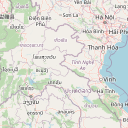


Leaflet | © OpenStreetMap contributors
| Kaupunki: | Dong Hoi |
| Maa: | Vietnam |
| IATA-koodi: | VDH |
| ICAO-koodi: | VVDH |
| Koordinaatit: | 17°30′54″N, 106°35′26″E |
| Kiitotiet: |