Perales Airport
| Kaupunki: | Ibagué |
| Maa: | Kolumbia  |
| IATA-koodi: | IBE |
| ICAO-koodi: | SKIB |
| Koordinaatit: | 4°25′17″N, 75°7′59″W |
| Kiitotiet: |
Suunta: 14/32, Pituus: 1800 x 30 m, korkeus: 928 m |
Sijainti karttalla
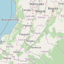


Leaflet | © OpenStreetMap contributors
| Kaupunki: | Ibagué |
| Maa: | Kolumbia |
| IATA-koodi: | IBE |
| ICAO-koodi: | SKIB |
| Koordinaatit: | 4°25′17″N, 75°7′59″W |
| Kiitotiet: |
Suunta: 14/32, Pituus: 1800 x 30 m, korkeus: 928 m |