Uru Harbour Airport
| Kaupunki: | Atoifi |
| Maa: | Salomonsaaret  |
| IATA-koodi: | ATD |
| ICAO-koodi: | AGAT |
| Koordinaatit: | 8°52′23″S, 161°0′39″E |
| Kiitotiet: |
Suunta: 13/31, Pituus: 844 x 15 m, korkeus: 4 m |
Sijainti karttalla
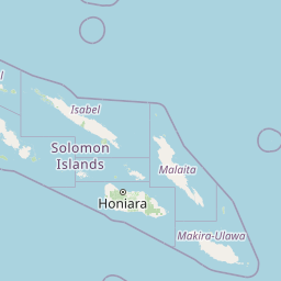


Leaflet | © OpenStreetMap contributors
| Kaupunki: | Atoifi |
| Maa: | Salomonsaaret |
| IATA-koodi: | ATD |
| ICAO-koodi: | AGAT |
| Koordinaatit: | 8°52′23″S, 161°0′39″E |
| Kiitotiet: |
Suunta: 13/31, Pituus: 844 x 15 m, korkeus: 4 m |